Flood Stage information for Pinole Creek at San Pablo Avenue
|
|
Flood Stage Estimate for Pinole Creek @ San Pablo Avenue PSP on Pinole Creek, Pinole |
|
|
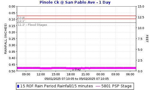
Flood stages have been determined for this stream gauge located just upstream (east) of San Pablo Road on Pinole Creek in San Pablo. Please report flooding location and time: Click to report Flooding from Pinole Creek including time and location. The plot below shows the latest stage data with horizontal lines for the gauge stages at locations in the table below. |
||
|
|
||
FLOOD STAGESReadings at the gauge that could indicate flooding at the location. |
||
|
Flooding Order |
Gauge Stage |
Flooding Locations |
|
3rd |
12.8 |
Brandt Court |
|
2nd |
12.1 |
Between Pear Street and Prune Street | 500 ft upstream of Railroad Avenue | City of Pinole WWTP |
|
1st |
11.2 |
Upstream of San Pablo Avenue |
How was the flood stage developed? |
Computer ModelA HEC-RAS Model was made using LiDAR, survey data and some as-built plans. Flows were estimated using USGS StreamStats. |
|
Certainty of flood stage accuracy? |
We have 80% confidence in the model results.The survey data reflected differences in the channel bottom since the date the LiDAR was flown in approximately 2008. We did not survey every bridge. To be fully confident in the model we would need to survey the entire creek reach. LiDAR stands for Light Detection and Ranging. It's a technology that uses laser light to measure distances. |
|
Future Efforts |
The FC District may send postcard information to properties along the creek. This could include information on how they can help fine-tune the flood stage by reporting where and when flooding is experienced. |
|
|
View Pinole Creek @ San Pablo Avenue flood stages: PSP Direct Plot Link. |
||
|
Click to report Flooding from Pinole Creek including time and location. |
||
|
Click here for Flood Stage Report and Maps |
||
Date: 3/13/2026 12:21:58
File location: G:\fldctl\Hydrology\Streamflow\Flood Stage Information Web Docs\AA-Merge_HTML.docm