Flood Stage information for Walnut Creek at Ygnacio
|
|
Flood Stage Estimate for Walnut Creek @ Ygnacio WCY on Walnut Creek, Walnut Creek |
|
|
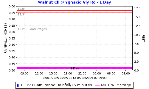
Flood stages have been determined for this stream gauge located just upstream (south) of Ygnacio Vly Road on Walnut Creek Channel in Walnut Creek. Please report flooding location and time: Click to report Flooding from Walnut Creek including time and location. The plot below shows the latest stage data with horizontal lines for the gauge stages at locations in the table below. |
||
|
|
||
FLOOD STAGESReadings at the gauge that could indicate flooding at the location. |
||
|
Flooding Order |
Gauge Stage |
Flooding Locations |
|
3rd |
16.8 |
Civic Park West Side |
|
2nd |
16.3 |
Civic Drive | Civic Park East Side |
|
1st |
12.2 |
Arroyo Way |
How was the flood stage developed? |
Computer ModelExisting models were used for this gauge. Flows from existing hydrology points were used in the model. Some of these were estimated using proportion to other return period scenarios. |
|
Certainty of flood stage accuracy? |
We have 80% confidence in the model results.The model was developed from as-built plans of the creek channel as well as LiDAR for the more natural area area around Civic Park. The reaches that are underground from North Broadway under the shoping areas was modeled from plans. Under the shoping area LiDAR stands for Light Detection and Ranging. It's a technology that uses laser light to measure distances. |
|
Future Efforts |
The FC District may send postcard information to properties along the creek. This could include information on how they can help fine-tune the flood stage by reporting where and when flooding is experienced. |
|
|
View Walnut Creek @ Ygnacio flood stages: WCY Direct Plot Link. |
||
|
Click to report Flooding from Walnut Creek including time and location. |
||
|
Click here for Flood Stage Report and Maps |
||
Date: 3/13/2026 12:22:08
File location: G:\fldctl\Hydrology\Streamflow\Flood Stage Information Web Docs\AA-Merge_HTML.docm