Flood Stage information for Walnut Creek at Marsh Drive
|
|
Flood Stage Estimate for Walnut Creek @ Marsh Drive WMR on Walnut Creek, Concord |
|
|
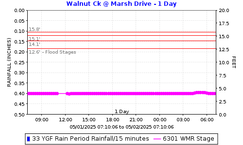
Flood stages have been determined for this stream gauge located on Marsh Drive Bridge over Walnut Creek in Concord. Please report flooding location and time: Click to report Flooding from Walnut Creek including time and location. The plot below shows the latest stage data with horizontal lines for the gauge stages at locations in the table below. |
||
|
|
||
FLOOD STAGESReadings at the gauge that could indicate flooding at the location. |
||
|
Flooding Order |
Gauge Stage |
Flooding Locations |
|
4th |
15.8 |
SE corner of Buchanan Field Airport |
|
3rd |
15.1 |
Rancho Diablo Mobile Home Park |
|
2nd |
14.1 |
Pacheco Slough, 5700 ft upstream of Walnut Creek (Pacheco Creek) |
|
1st |
12.6 |
Martinez Gun Club (Pacheco Creek) |
How was the flood stage developed? |
Computer ModelExisting models were used for this gauge. |
|
Certainty of flood stage accuracy? |
We have 95% confidence in the model results.The model was developed by the Corps of Engineers and has possibly been modified by others. We updated a replaced bridge. |
|
Future Efforts |
The FC District may send postcard information to properties along the creek. This could include information on how they can help fine-tune the flood stage by reporting where and when flooding is experienced. |
|
|
View Walnut Creek @ Marsh Drive flood stages: WMR Direct Plot Link. |
||
|
Click to report Flooding from Walnut Creek including time and location. |
||
|
Click here for Flood Stage Report and Maps |
||
Date: 3/13/2026 12:22:11
File location: G:\fldctl\Hydrology\Streamflow\Flood Stage Information Web Docs\AA-Merge_HTML.docm