During a storm, the creek will rise to a peak and then fall. The peak flow is the highest flow (and normally also the highest level or stage) the creek water rises to during the storm. Sometimes we say the creek will crest or has crested; same thing as peak.
The Flood Stage Lines on the stream stage plots are the stages (heights) at which we can anticipate flooding in the areas near that stream gauge. The Flood Stage Lines on most of the plots are labeled "Draft" or "Sample" since we are still in process of performing the research and engineering calculations to determine those stages.
Stage is usually in feet and can be the elevation from sea level (like the Marsh Ck Reservoir) or an arbitrary elevation not relative to sea level or bottom of the creek.
The NWS Radar Products are imported to this RainMap are not generated by the Contra Costa County
Flood Control and Water Conservation District.
Why does the radar show rain when it's not raining? When it is not raining, the NOAA NEXRAD radars go into "Clear Air Mode" where their sensitivity increases. This mode detects
airborne dust and particulate matter. Rotating wind turbine blades can also impact radar readings. We see their impact
in the the areas west of Rio Vista and around Altamont Pass.
High Resolution Rapid Refresh (HRRR): This is a new forecast product from the NWS that is being perfected and implemented in many forecast products. Find out more about HRRR at the HRRR website.
When the watersheds are wet, there is more chance of flooding when a big storm comes. We can look at past rainfall to get an idea of how wet the watersheds are.
A table pops up when you click on a rain data point (blue "
+
" or data number). The table shows you the rain that has fallen so far in the season, in the last 30-days, and in the last 7-days. When the rain depths are around
7",
3", and
5" respectively, and if we have a forecast of
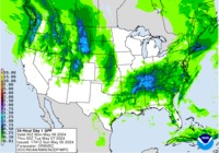
2" of rain in the next 24 hours (see
24-hour QPF map), you should expect some level of flooding.
You can find out more about the 7-5-3-2 protocols at our Flood Forecast Information Page.
Click the image below.
CDEC collects data from many different entities and station types. The Flood Control District sends its data to CDEC on
a regular basis and various weather agencies use the data to proof their weather predictions and radar readings. Not
all data sent to CDEC is corrected if we make adjustments to our data due to errors.
You will see links to the CDEC website at the bottom of the station popup menus. On mobile divices the CDEC Map link will not show since the map does not work well on mobile devices.
Note: The CDEC three letter tag is sometimes different than the Flood Control District three letter tag.
The data tool was developed to allow easier use of the data provided through links in the rain gauge popup windows. The tool was created in MS Excel, is open source, is not write protected, nor edit protected. The tool may be downloaded from the County website at the following link. It will help reformat the data in a more usable form.
Clicking a blue "+" or a data label will open a window with station information, a table of data, and a plot.
The table cell colors for the 7-day, 30-day and Season amounts will change when the 7-5-3 protocols are met. See Flood
Forecasting 7-5-3-2 in the Info menu list.
Storm rainfall resets at each gauge after 12 hours without rain.
The battery plots with flat voltage lines are for stations with batteries charged using household current. The battery
plots with wavy voltage lines are for stations with batteries charged using solar panels. They gain or lose charge with
the sunshine.
One of the most common station maintenance issues is battery charging failure which can be due to a variety of reasons.
The "Dataset:" and "Update:" text will turn
red if it has been more than 1 hour since the last data update.
Rainfall, Water Level, and Battery voltage = No precipitation has occurred in the select time period.
= Data missing, gauge has not reported in last 24 hours.
Point color: Point color will change when 7-5-3 protocols are met. Click 7-5-3-2 menu or icon for more information.
Radars: The Radar layer provides a view of the relative rainfall intensity. See also the "Radar Info" button under the "More" menu.
This map was created from provisional data that has not been checked by related public agencies.
The County and Flood Control District do not warrant the accuracy of this map, and no decision involving a risk of economic loss or physical injury should be made from the data available on this site.